The Market Is Heating Up
Early wildfire detection sits at the crossroads of several transformative trends in cleantech. Advances in AI, IoT sensors, nanosatellites, and edge computing are converging to shrink the wildfire detection window from hours to minutes; a difference that can determine whether a blaze consumes 10 acres or 10,000.
However, many agencies and utilities deploy disparate systems that rarely “talk” to one another, a gap that’s slowing widespread adoption.
Innovation is abundant, but uptake is constrained by funding limitations, operational silos, and integration challenges, rather than a lack of technology. Still, pressure from insurers and liability exposure is driving more organizations to invest in early detection as a form of financial risk management. Winners will be those who integrate detection and suppression into seamless systems, bridging data, automation, and physical firefighting capability.
From the Forest Floor: IoT and Gas Sensors
Dryad is a key example of a ground-up approach. The company deploys solar-powered, AI-enabled gas sensors in forests to identify trace gases released in the earliest stages of combustion, long before flames are visible. By connecting thousands of sensors via an IoT mesh network, Dryad’s system can detect fires within minutes, a dramatic improvement over camera or satellite-based models that can take hours.
What’s compelling is the company’s ambition to combine detection and suppression through “SilvaGuard,” an autonomous drone system designed to extinguish small fires immediately after detection. If proven at scale, this model could represent a paradigm shift: moving from alert-based systems to active wildfire prevention ecosystems.
However, sensor networks can face operational hurdles: dense deployment requirements and calibration needs make them most suitable for high-risk, high-value regions where the economics of early detection are easiest to justify.
From Space: Satellites and AI-Driven Thermal Intelligence
Orbiting above, innovators like OroraTech and ICEYE are redefining what’s possible from space.
OroraTech, spun out from the Technical University of Munich, has developed a thermal-infrared nanosatellite constellation capable of identifying fire hotspots as small as four square meters, even through smoke or at night. Its biggest differentiator is on-orbit AI processing where data is analyzed directly in space within minutes, instead of waiting for downloads to ground stations that can take over an hour. This dramatically reduces the time from ignition to alert.
OroraTech’s coverage also fills what it calls the “afternoon gap,” when most public satellites miss critical activity due to orbit schedules. With plans for a 100-satellite network, it’s on track to deliver near-continuous global wildfire monitoring, a leap toward predictive, autonomous risk management.
ICEYE, based in Finland, has taken a complementary approach using Synthetic Aperture Radar (SAR) satellites. Its technology penetrates smoke and clouds, providing near-real-time mapping of fire damage even when optical imagery fails. During the 2025 Los Angeles wildfires, ICEYE achieved over 99% precision in identifying destroyed structures, feeding rapid data to emergency managers and insurers within 24 hours, a stark contrast to traditional methods that take weeks.
The company’s scale is unmatched, with over 50 active satellites and production ramping toward 150 per year. While ICEYE’s model is more capital-intensive, it’s one of the few offering both satellite manufacturing and data services, giving it a defensible market position.
From the Hills: Smart Cameras and Visual Intelligence
Pano AI brings precision and immediacy through dual ultra-HD cameras mounted on towers, delivering 360° coverage and scanning every minute. These systems have proven capable of detecting fires within 3–15 minutes in regions like Colorado and Oregon.
While camera technology itself isn’t new, Pano’s differentiator lies in AI-powered verification that reduces false positives and enhances reliability. Its partnerships with utilities and over 250 first-responder agencies underscore strong market traction in the U.S.
However, scalability is a challenge: each camera station can cost around $50,000 per year, limiting deployments in resource-constrained regions. Moreover, reliance on human validation in its alert process slows automation, a gap that competitors leveraging fully AI-driven models are quickly closing.
From the Cloud: Data Fusion and Accessibility
At the opposite end of the spectrum, Satellites on Fire (Argentina) is building a bridge between sophistication and accessibility. Rather than investing in proprietary hardware, it fuses public satellite feeds, camera inputs, and community-sourced reports into a unified AI platform that pushes alerts via WhatsApp and SMS, a clever adaptation for low-connectivity regions.
This approach democratizes wildfire intelligence, offering near-real-time alerts every five minutes at a fraction of the cost of more hardware-heavy systems. While technically replicable by larger firms, the platform’s community network of 50,000+ contributors create a feedback loop that strengthens its models over time, an example of innovation grounded in inclusivity rather than capital intensity.
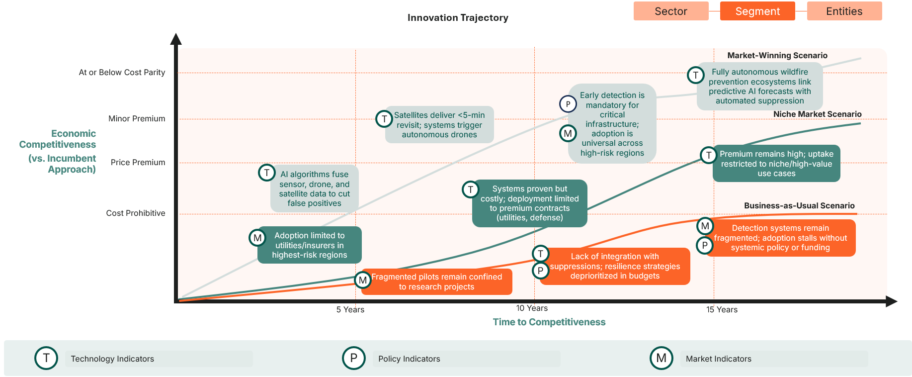
Trajectory of Wildfire Early Detection Innovation – Market Uptake Scenarios
What’s Next: The Innovation Frontier
The frontier of wildfire detection lies not in any single technology but in system integration. The next generation of innovators will combine detection, forecasting, and suppression into continuous, autonomous ecosystems.
In the next decade, the most competitive systems will pair AI-driven predictive models with automated drone and satellite coordination, achieving sub-five-minute detection-to-response cycles. These solutions will likely become mandated for critical infrastructure and standard practice in high-risk regions.
Additionally, cross-sector convergence is reshaping investment and resilience strategies. Dual-use applications such as wildfire detection tech repurposed for defense or flood monitoring, are attracting more stable funding and insulating companies from policy volatility. Tech giants like Google’s FireSat, NVIDIA, and IBM are entering the space, bringing massive computing power and capital that could accelerate the path from pilot to planet-scale deployment.